No Products in the Cart
Call Us: +1 866 300 9012
contact@measur.caGone are the days of waiting for concrete to cure before verifying the accuracy of pours. Traditional FF/FL evaluation methods were time-consuming, taking up to a full day, and leaving no room for potential costly rework the following day. However, with the new faster solution you can reduce the process to mere minutes while reducing the need for rework, allowing your team to correct concrete slabs before they even harden.
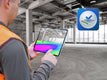
Introducing Flatness Check, a user-friendly augmented reality app that's iOS-compatible. It allows immediate on-site visualization of floor flatness and levelness, ensuring concrete pours are completed on schedule with improved quality of work. With Flatness Check, you can save time, effort, and money by eliminating expensive rework. Simply connect the app to your FARO Focus Laser Scanner to access and leverage point cloud data for accurate flatness evaluation.
 |
Same-day AssesmentWith FARO laser scanners, the flatness and levelness analysis can be performed the same day a slab is poured, controlled via the Flatness Check App on an iPad. Other methods require the concrete to be cured before doing so. |
|
|
SpeedTraditional methods (dipsticks, straightedge tests, wheel-based profilers, etc.) are slow and tedious, and floor analysis can take up to 48 hours to complete. Laser scanners, by contrast, generate a 3D heatmap of the slab in minutes while leveraging AR technology to identify the out of tolerance areas needed to be fixed in only an hour. |
 |
AccuracyWhile a laser scanner produces a precise, complete visual representation of the site, traditional measurement data is incomplete due to a limited number of measurement points, increasing risk that mistakes are not caught. |
|
|
Less ReworkWhile a laser scanner produces a precise, complete visual representation of the site, traditional measurement data is incomplete due to a limited number of measurement points, increasing risk that mistakes are not caught. |
|
|
VerifiableWith traditional methods, the results can vary from person to person, with no true record of where the measurements were taken spatially. Laser scanning provides a 3D-documented result, allowing for independent investigation and data testing. |
 |
 |
 |