No Products in the Cart
Call Us: +1 866 300 9012
contact@measur.ca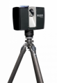

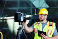
Scan, visualize, and deliver faster than ever with FARO scanners! Successfully complete projects in minimum time with no disruptions due to reliable and easy-to-use hardware.

With one-button operations and fully-integrated software, you can begin collecting data within minutes. Mapping massive heritage sites to 3-storey buildings is just a click away!

Create perfectly aligned, georeferenced point clouds with the touch of a button through FARO Scene. With multiple software suites, choose the set-up perfect for your application.

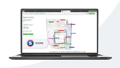
FARO Sphere
FARO Sphere is a cloud-based information platform that provides a centralized, collaborative experience.

FARO As-Built
FARO As-Built Software is a CAD & BIM modeling and drawing software that is intuitive and easy to use.
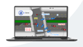
FARO Built-It Construction
FARO BuildIT Construction Software is a complete design software solution for continuous construction verification
FARO SCENE
Industry-leading Software for intuitive, efficient 3D point cloud capture, data processing and registration
FARO Zone 2D
FARO Zone 2D is a crime scene sketch software that eliminates the monotony of hand drawing scene and site diagrams

FARO Zone 3D
FARO Zone 3D accident reconstruction software makes it easy to make 3D drawings of an event and produce detailed visuals
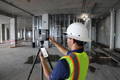
Faro's advanced 3D laser scanning systems boost in-field productivity by providing quick and accurate in-field registration, comprehensive deliverables, and a robust processing workflow. Scan with confidence and produce the survey-grade results needed in less time. In the office, Faro Scene allows you to manage high-quality 3D data fully georeferenced for high-accuracy projects.
Faro's advanced 3D laser scanning systems boost in-field productivity by providing quick and accurate in-field registration, comprehensive deliverables, and a robust processing workflow. Scan with confidence and produce the survey-grade results needed in less time. In the office, Faro Scene allows you to manage high-quality 3D data fully georeferenced for high-accuracy projects.

Traditional methods make the crash and forensic workflow process very inefficient causing officers to spend more time on scene with unreliable deliverables. FARO 3D laser scanning enhances investigations by reducing the time taken to document the scene, giving more accurate deliverables in less time, and increasing the likelihood of better outcomes in court. Some sample applications include crime scene investigation, crash scene analysis, arson investigation, courtroom presentation, safety planning, failure investigation, and more.
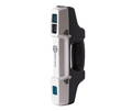
Compact and portable laser scanner for quick and easy 3D modelling. Complete a 360° scan in just 45 seconds. The built-in panoramic camera adds true colour to scans.
When affordability meets industry-leading technology! The X150 is an easy-to-use terrestrial scanner up to 150 meters for quick and seamless surveys.
With a range of over 100 meters, the XH120 is the perfect tool for outdoor applications. Its lightweight and compact design also makes it an ideal choice for indoor surveys.
Scan complete scenes and objects within seconds with the Stonex F6 handheld scanner. With a range from 0.5 - 4.5 meters, the F6 is ideal for scanning complex geometry.