Call Us: +1 866 300 9012

contact@measur.ca
SHOPPING CART

No Products in the Cart

TOTAL:
$0.00
The Emlid Reach RS3 is a cutting-edge surveying and mapping device that stands out for its remarkable features. This article will explore the top four features of the Emlid Reach RS3, providing a comprehensive overview and highlighting the key specifications of this impressive device.

Understanding the Emlid Reach RS3

The Emlid Reach RS3 is a professional-grade Global Navigation Satellite System (GNSS) receiver designed for high-precision positioning. It integrates advanced technology, robust construction, and user-friendly features to deliver unparalleled performance for surveyors, geodesists, and GIS professionals.

An Overview of the Emlid Reach RS3

The Emlid Reach RS3 combines a powerful GNSS module with an integrated IMU and a multi-band antenna, ensuring accurate and reliable positioning even in challenging environments. It supports multiple satellite constellations, including GPS, GLONASS, Galileo, BeiDou, and SBAS, providing a wide range of satellites to enhance positioning accuracy.

With its state-of-the-art technology, the Emlid Reach RS3 offers a comprehensive solution for precise and efficient data collection. Whether you are conducting land surveys, mapping projects, or geodetic measurements, this GNSS receiver is designed to meet your needs.

One of the standout features of the Emlid Reach RS3 is its GNSS signal tracking capabilities. It supports a wide range of signals, including L1, L2, L5, L6, G1, G2, G5, B1, B2, E1, E5a, E5b, and E6. This extensive signal compatibility ensures that you can achieve highly accurate positioning results across various frequency bands.

Key Specifications of the Emlid Reach RS3

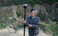
Before delving into the outstanding features of the Emlid Reach RS3, let's take a closer look at the key specifications that contribute to its exceptional performance:

GNSS Signal Tracking: The Emlid Reach RS3 supports a wide range of GNSS signals, including L1, L2, L5, L6, G1, G2, G5, B1, B2, E1, E5a, E5b, and E6. This extensive signal compatibility ensures that you can achieve highly accurate positioning results across various frequency bands.

Positioning Accuracy: The Emlid Reach RS3 offers outstanding positioning accuracy. It can achieve a horizontal accuracy of 5 mm + 0.5 ppm RMS and a vertical accuracy of 10 mm + 1 ppm RMS. This level of precision is crucial for applications that require highly accurate positioning, such as land surveying and geodetic measurements.

Real-Time Kinematic (RTK) Solution: The Emlid Reach RS3 supports real-time kinematic (RTK) positioning, allowing you to obtain centimeter-level accuracy in real-time. With an RTK solution, you can achieve precise positioning results even in dynamic environments. The Emlid Reach RS3 can handle baselines of up to 60 km and provides position output at a rate of up to 8 Hz.

Communications: The Emlid Reach RS3 offers various connectivity options to ensure seamless data transfer. It features Wi-Fi, Bluetooth, LoRa, and USB connectivity, allowing you to easily connect the receiver to your preferred device or network. This flexibility in communication options enhances the usability and versatility of the Emlid Reach RS3.

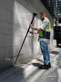
Ruggedness: The Emlid Reach RS3 is built to withstand the demands of fieldwork. It boasts an IP67-rated dustproof and waterproof construction, ensuring that it can withstand harsh environmental conditions. This ruggedness makes the Emlid Reach RS3 suitable for use in challenging terrains and adverse weather conditions.

Overall, the Emlid Reach RS3 is a powerful and reliable GNSS receiver that offers exceptional performance and accuracy. With its advanced technology, robust construction, and user-friendly features, it is an ideal choice for professionals in the surveying, geodesy, and GIS industries.

Feature 1: Superior Accuracy

IMU Tilt Compensation For More Accurate Results

The Emlid Reach RS3 comes equipped with an IMU-based tilt compensation allowing users to take measurements at up to 60 degrees of tilt while staying within 2 centimetres of accuracy. This happens in real-time and increases the speed and accuracy of your surveys.

How the Emlid Reach RS3 Achieves High Accuracy

The Emlid Reach RS3 employs cutting-edge GNSS technology, including multi-frequency and multi-constellation support. By simultaneously tracking signals from multiple satellites, it significantly reduces ionospheric errors and minimizes the impact of multipath interference, resulting in highly precise positioning measurements.

Benefits of High Accuracy in Surveying and Mapping

High accuracy is crucial in surveying and mapping applications, as it ensures reliable results and minimizes errors. With the Emlid Reach RS3's superior accuracy, professionals can confidently undertake sensitive tasks such as cadastral surveys, construction layout, and infrastructure development, where precision is paramount.

Feature 2: Long-Range Connectivity

The Emlid Reach RS3 offers unparalleled connectivity options, facilitating efficient data transfer and remote control capabilities, even in remote and challenging environments.

Exploring the Connectivity Options of the Emlid Reach RS3

Equipped with Wi-Fi, Bluetooth, LoRa, and USB interfaces, the Emlid Reach RS3 ensures seamless integration with various data transmission methods. This versatility enables surveyors to connect to their preferred devices and transfer data effortlessly, eliminating the need for cumbersome cables and adapters.

The Impact of Long-Range Connectivity on Field Work

The ability to transfer data wirelessly over long distances enhances fieldwork productivity and reduces downtime. With the Emlid Reach RS3's long-range connectivity, professionals can collect, access, and share data in real-time, thereby streamlining workflows and enhancing collaboration in the field.

Real-Time Kinematics (RTK)

Multiple Connectivity Options
NTRIP Corrections

Feature 3: Rugged Design for Field Work

Surveying and mapping tasks often take place in harsh and demanding environments, where durability and reliability are crucial. The Emlid Reach RS3's rugged design ensures it can withstand the rigors of fieldwork, providing peace of mind to professionals operating in challenging conditions.

The Durability of the Emlid Reach RS3

The Emlid Reach RS3 boasts an IP67-rated dustproof and waterproof enclosure, protecting it from water immersion and dust ingress. Additionally, its robust construction shields it from accidental drops, impacts, and extreme temperatures, ensuring consistent performance in any situation.

Why a Rugged Design Matters in Surveying Equipment

A rugged design is essential for surveying equipment because fieldwork entails exposure to various elements and potential hazards. By investing in a robust device like the Emlid Reach RS3, professionals can rest assured knowing that their equipment will withstand the demands of their work environment, keeping their operations running smoothly.

Feature 4: User-Friendly Interface

The Emlid Reach RS3 incorporates a user-friendly interface that simplifies operation and enhances productivity. Its intuitive design empowers surveyors and mapping professionals to complete their tasks efficiently and effectively.

Navigating the Interface of the Emlid Reach RS3

The Emlid Reach RS3's interface is designed with the user in mind. Its intuitive menus, clear indicators, and straightforward controls enable effortless navigation and quick access to essential functions. Users can easily configure settings, monitor status, and perform necessary adjustments, minimizing training requirements and maximizing productivity.

The Role of User-Friendly Design in Efficient Field Work

A user-friendly interface is vital for efficient fieldwork as it reduces the learning curve, minimizes errors, and accelerates data collection and processing. With the Emlid Reach RS3's user-friendly design, professionals can focus on the task at hand, ensuring accurate and timely results, even in demanding field conditions.
In conclusion, the Emlid Reach RS3 stands out with its top five features: superior accuracy, long-range connectivity, rugged design, and user-friendly interface. Whether conducting precise surveys, mapping extensive areas, or working in demanding environments, professionals can rely on the Emlid Reach RS3 to deliver exceptional performance. With its advanced capabilities and robust construction, this device sets a new standard in the surveying and mapping industry.

RELATED POSTS

How the CHCNav RS10 Handheld SLAM Scanner is Reshaping the Surveying and Construction Industries
A handheld 3D scanner for surveying, construction, and other industries is a portable device used to capture detailed three-dimensional data...
Top Four Features of the Emlid Reach RS3
The Emlid Reach RS3 is a cutting-edge surveying and mapping device that stands out for its remarkable features. This article...
Understanding Faro's Warranty Options
Investing in high-quality hardware comes with the expectation of reliability and performance. To enhance the customer experience and provide peace...
Get in touch
Give us a call or drop by anytime, we will answer all enquiries within 24 hours on business days. We will be happy to answer your questions.

Contact Information

We would love to hear from you! Our team is always here to help.

  • +1 866 300 9012

  • contact@measur.ca

  • Vancouver, British Columbia

    Calgary, Alberta

    Mississauga, Ontario

    Montreal, Quebec

Name*:

Phone*:

Company*:

Email*:

Message:

Speak with an Expert

Name:

Company:

Phone:

Email:

Message:

BACK TO TOP